Overview & Map
Cedarock Park features a network of trails that includes approximately 4 miles of hiking trails and 6 miles of equestrian trails. All trails are marked with colored blazes on trees every tenth of a mile. Keep an eye out to make sure you’re on the trail you intended! None of the trails are particularly strenuous hikes, but they do involve some inclines and are mostly natural surface so please use caution and know your abilities.
In case of an emergency, please note the number on the nearest trail blaze and report it to park staff or emergency services if you call for help.
Click Here to view a map of the trails.
Trails
Equestrian Trail (Orange Blazes)
Cedarock offers 6 miles of dedicated equestrian trail. Horses are allowed only on the Equestrian Trail (orange blazes). Please note that the Equestrian Trail involves a shallow creek crossing and several short wooden bridges where it winds over Rock Creek. The trail consists of 3 loops comprising 6 miles that wend their way through the park. There is a new mile of connector trail that will link the new Equestrian Center and dedicated equestrian park entrance to the rest of the trail. This is a beautiful wooded trail that offers hills, creek crossings, flat areas, and beautiful views of the whole park.
Spoon Branch Trail (Blue Blazes)
The first trail that you encounter as you enter the park, the Spoon Branch Trail (blue blazes) offers 2 miles The first trail that you encounter as you enter the park, the Spoon Branch Trail, offers 1.3 miles of easy to moderate hiking along Rock Creek and its tributaries. The trail begins beside the Historical Farm and follows alongside the goat and sheep pasture into the woods. After crossing the bridge over Rock Creek, the trail quickly changes over to mature, open woodland.
Rock Creek Trail (Yellow Blazes)
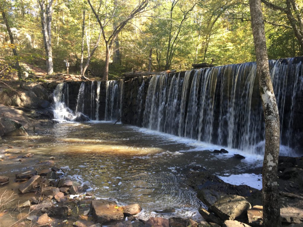
Rock Creek Trail offers 1.7 miles of hiking through mature hardwood forest. You can access this trail from the trailhead above Obel’s Shelter.
You will enjoy views of the creek throughout the trail, moderate inclines, and spectacular views of the waterfall over the old mill dam. This trail is a relaxing walk for new and seasoned hikers.
Spoon Branch/Rock Creek Connector Trail (White Blazes)
The Connector Trail features upper and lower sections linking the Spoon Branch and Rock Creek Trails. The lower section follows the lowlands along the creek, so beware of swampy footing in wet weather. The newer upper connector meanders upland, offering a drier alternative dotted with wildflowers in the spring.
Curtis Mill Trail (Purple Blazes)
This half-mile trail is the park’s only paved trail. It is accessible from the parking lot near the Wellspring Disc Golf Course and playground. This popular walk takes you to the waterfall over the old mill dam. It also connects to the Rock Creek Trail providing the opportunity to continue your hike, or you can turn back to return to the trailhead. This is a great choice if you’re looking for a short walk and a visit to the waterfall, or for those needing a more accessible trail than the natural surface trails can offer.